| Inertial Navigation System |
Pls click or email to
mh_elec@126.comorjacky@mh-elec.com
1. Brief introduction
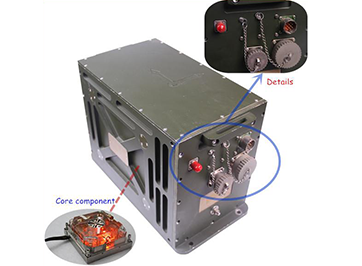
LS10 land laser inertial integrated navigation system is a commonly used integrated navigation system, which is suitable for unmanned vehicle platforms. This products is mainly composed of a laser gyro, a quartz flexible accelerometer,
an embedded navigation computer, an auxiliary peripheral hardware circuit, a secondary power supply component, a vibration system and so on. This system can continuously and real-time provide the attitude and heading info, instant position (longitude and latitude), velocity of the vehicles. It can be operated by driver navigator and CDU, to provide detailed navigation info according to driving mission plan.
2. Features
1). Anti interference autonomous north seeking
Under disturbed conditions, north seeking accuracy≤0.06°/h(1σ)
This system uses the enhanced Kalman filter fusion algorithm, can rapidly complete high-precision north seeking during the situation of engine idle speed, personnel get off and so on, with the alignment function during marching forward.
2). Strong ability of autonomous navigation and integrated navigation
Pure inertial navigation accuracy≤1n mil/h(1σ), position accuracy is able to be≤0.2%D by integrated an odometer.( D means Total Mileage)
A variety of navigation mode, can be combined with not only GNSS system (GPS, BD, GLONASS), to realize the integrated navigation function, but also available of pure inertial navigation function, and can combined with MDP, altimeter and other sensors, to achieve multi sensor fusion autonomous navigation function.
3). Good scalability
The system can be compatible with any one or several systems of satellite navigation system, including GPS, BD, GLONASS, for integrated navigation. With selectable positioning accuracy.
4).Varied interfaces
It can be compatible with RS422, CAN and other interfaces to facilitate the application of different vehicle platforms.
5). Auto Save Function
3. Performances
|
Sr. No.
|
Item
|
Grade
|
Remark
|
|
A
|
B
|
|
system performance
|
|
1
|
North seeking accuracy
|
1mil
|
2mil
|
(1σ)
|
|
2
|
Attitude accuracy
|
0.2mil
|
1mil
|
(1σ)
|
|
3
|
North seeking time
|
5min
|
5min
|
(1σ)
|
|
4
|
Course keeping/stand on accuracy
|
1mil/h
|
2mil/h
|
|
|
5
|
Pure inertial navigation accuracy
|
≤1n mil
|
≤1.5n mil
|
(1σ)
|
|
6
|
Positioning accuracy(integrated odometer)
|
0.2%D
|
0.5%D
|
D means mileage
(Km)
|
|
7
|
Horizontal positioning accuracy
(Integrated GNSS)
|
Single point : 2m/5m(1σ)
DGPS:0.5m(1σ)
RTK:50px+1ppm(1σ)
|
(1σ)
|
|
8
|
Velocity accuracy
(Integrated GNSS)
|
0.02m/s
|
|
|
Core component
|
|
9
|
RLG bias stability
|
≤0.01°/h
|
≤0.02°/h
|
(1σ)
|
|
10
|
RLG scale factor
|
2PPm
|
5PPm
|
|
|
11
|
Accelerometer bias stability
|
≤0.05mg
|
0.1mg
|
(1σ)
|
|
Environmental suitability
|
|
12
|
Shock
|
30g
|
30g
|
|
|
13
|
Working temperature
|
-40℃~65℃
|
-40℃~65℃
|
|
|
14
|
Storage temperature
|
-45℃~75℃
|
-45℃~75℃
|
|
|
15
|
Vibration
|
Meet the vehicle vibration requirement of GJB150.16A-2009
|
|
Physical features
|
|
16
|
Size
|
368 mm×245 mm×255 mm
|
|
|
17
|
Weight
|
13.5Kg
|
|
|
18
|
Power supply
|
18VDC~36VDC
|
|
|
19
|
Power dissipation
|
Working: 50W
|
|
|
Start: 150W
|
|
|
Interface features
|
|
20
|
Interface
|
RS232、RS422、CAN
|
Selectable
|
|
21
|
MTBF
|
≥1500h
|
|
|
22
|
Data refresh rate
|
100Hz
|
|
|
23
|
Band rate
|
115200bps
|
|
|
24
|
Memory
|
32G
|
|
|
Measurement range
|
|
25
|
Azimuth measurement range
|
±180°
|
|
|
26
|
Pitch measurement range
|
±90°
|
|
|
27
|
Roll measurement range
|
±90°
|
|
|
28
|
RLG angular rate
|
±300°/s
|
|
|
29
|
Acceleration
|
±15g
|
|
|
30
|
Latitude
|
<60°
|
|
4. Applications
(1). Unmanned driving
(2). Manned driving

5. Packages


Request A quick Quote (WhatsApp:+ 86-18792456795)